


Now Reading: Decoding Hurricane Forecasts: What the Cone of Uncertainty Means
-
01
Decoding Hurricane Forecasts: What the Cone of Uncertainty Means
Decoding Hurricane Forecasts: What the Cone of Uncertainty Means
Quick Summary
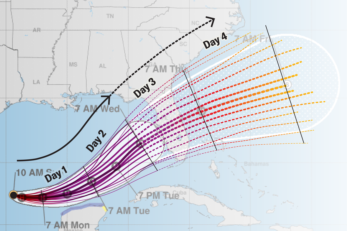
- Cone of Uncertainty: Used in hurricane forecasts to depict potential storm paths but requires careful interpretation.It shows the storm’s center rather than its full impact zone.
- Forecast Range: Error ranges are based on a five-year average, making predictions more accurate in the short term than long-term outcomes.
- Failure Margin: The cone encompasses possible paths 66% of the time; 33% of storms stray outside it.
- Storm Impact Beyond Cone: The cone does not account for storm size, wind intensity variations, rainfall distribution, and tornado potential.
- Visualization Innovations: Alternative graphics exploring multiple hurricane paths improve uncertainty communication by showing probabilities of different outcomes to help wiht public understanding.
- Updates Are Crucial: Forecasts evolve due to shifts in atmospheric patterns and storm dynamics. users should avoid anchoring their decisions on initial forecasts alone.
Other Resources:
Local National Weather Service reports provide area-specific details such as evacuation advisories or expected surge levels through interactive tools like NHC Hurricane Threats and Impacts maps.
Image Highlights:
- Various visualizations of forecast cones for hurricanes.
- Alternative visualization demonstrating likelihoods across potential paths.
Indian Opinion Analysis
Understanding hurricane forecasts is increasingly relevant globally due to climate change-driven weather anomalies that heighten vulnerabilities for nations like India with vast coastal populations prone to cyclones and monsoonal storms. The concept behind “cone-of-uncertainty” underscores how scientific forecasting balances precision against inherent unpredictability. For India’s meteorology agencies, notably IMD, adoption or adaptation of similar multi-path visualization methods could significantly enhance disaster preparedness among local communities.
Moreover, a key insight-storm impacts frequently enough extend beyond forecasted central trajectories-could inform infrastructure planning near Indian coastal cities vulnerable to high rainfall or tidal surges during cyclone events originating from Bay of Bengal or Arabian Sea regions. Regular updates from reliable sources must remain core guidance principles at the national level.
India’s continued investment in satellite monitoring systems mirrors global efforts toward improving forecasting accuracy but further steps ensuring better communication clarity around impacts (like those presented hear) might mitigate risks at ground levels effectively when cyclones strike annually along eastern shores every June-November interval aiding lives conservatively managing adaptions costs & evacuations predictably real-time decoupling alarming myths oft psychologically ignored-context kept false scale premature occurrences upon future seasons mentioning credible tide-surge assessment verified roadmap counterinverse intervals


Related Posts
Stay Informed With the Latest & Most Important News
Previous Post
Next Post


Advertisement


