

Now Reading: Jaishankar Dismisses ‘Greater Bangladesh’ Map Propaganda
-
01
Jaishankar Dismisses ‘Greater Bangladesh’ Map Propaganda
Jaishankar Dismisses ‘Greater Bangladesh’ Map Propaganda
Swift summary
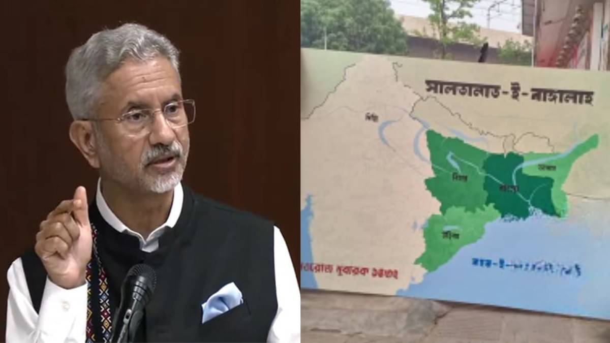
- Event: A controversial map showing parts of Northeast India, Bihar, Jharkhand, Odisha, and Myanmar’s Arakan State as Bangladeshi territory was displayed at Dhaka University.
- Source: The map was reportedly part of an exhibition referencing the Bengal Sultanate during Pohela Boisakh celebrations on April 14. Organizers denied political links and Bangladesh’s official fact-checking platform stated no evidence of the Islamist group ‘Saltanat-e-Bangla’ operating in Bangladesh.
- Group Involved: Allegations revolved around the radical Islamist organization ‘Saltanat-e-bangla,’ with supposed backing from Turkey’s Turkish Youth Federation NGO.
- India’s Response: external Affairs Minister Dr. S Jaishankar addressed concerns in Parliament stating that India is vigilant regarding such developments that may threaten national security while dismissing the claims as baseless.
- Turkey-Bangladesh Relations: Since PM Md Yunus took office, Turkish NGOs have expanded activities and bilateral defense cooperation has grown significantly under Turkish leadership aligned with President Erdogan’s policies.
Indian Opinion Analysis
The incident highlights political sensitivities in South Asia arising from regional dynamics and external influences like alleged Turkish involvement. While Bangladesh hosts diverse narratives within academia and civil society, India’s concern stems from any territorial propaganda potentially impacting its sovereignty or stirring tensions in border areas.
Turkey’s increasing engagement with Bangladesh suggests growing geopolitical complexity for India along its Eastern frontier; however, official denial by both Dhaka authorities and exhibition organizers tempers immediate alarm about state-level collusion against Indian interests.Vigilance combined with active diplomatic dialog will be critical for ensuring national security without disrupting broader regional stability.


Related Posts
Stay Informed With the Latest & Most Important News
Previous Post
Next Post


Advertisement


