


Now Reading: Loss of Key Satellites Raises Storm Forecasting Concerns Ahead of Peak Hurricane Season
-
01
Loss of Key Satellites Raises Storm Forecasting Concerns Ahead of Peak Hurricane Season
Loss of Key Satellites Raises Storm Forecasting Concerns Ahead of Peak Hurricane Season
Quick Summary
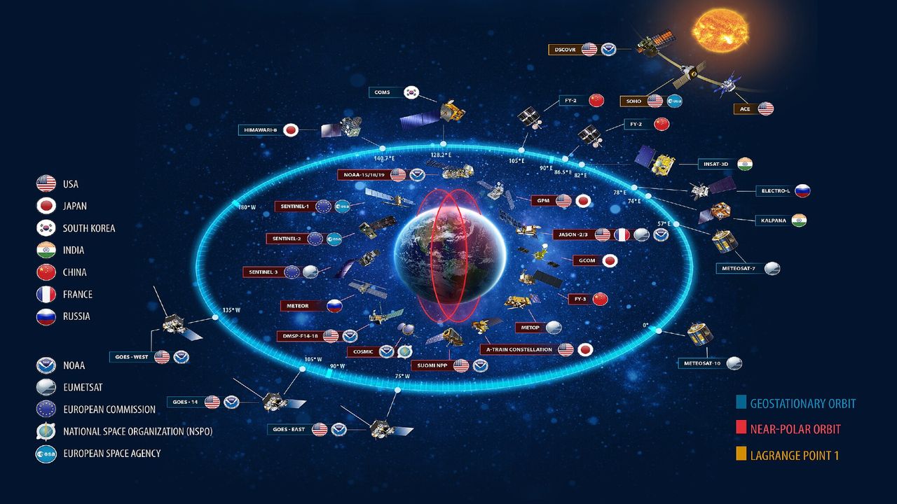
- Three key U.S. Defense Meteorological Satellite Programme (DMSP) satellites that provide critical hurricane forecasting data will discontinue operations starting July 31, 2025.
- The satellites, launched between 1999 and 2009 with a designed lifespan of five years, have operated for over 15 years but are being decommissioned due to cybersecurity risks and aging hardware.
- The DMSP satellites use specialized sensors to track hurricanes’ low-pressure centers and intensification signs, contributing significantly to forecasting accuracy-improving storm track predictions by up to 75% since 1990.
- Replacement tools include NOAA’s NOAA-20, NOAA-21, Suomi NPP satellites with advanced technology microwave sounders (ATMS). However,these instruments operate at lower resolution compared to DMSP sensor capabilities.
- A new defense meteorology satellite (ML-1A) was introduced in april 2025 but remains unavailable for civilian weather agencies like the National Hurricane Center.
- Ancient delays in funding and development led to cancellation or postponement of replacement satellite programs such as NPOESS and DWSS over the last two decades.
- The loss comes during the ongoing Atlantic hurricane season until November 30, which is forecasted above average with predictions of six to ten hurricanes.
Indian Opinion Analysis
the loss of three critical weather satellites raises concerns about global disaster preparedness during an increasingly challenging climate era marked by frequent extreme weather events like hurricanes-a reality not confined geographically but one relevant even for countries like India.With advancements in cyclone early warning systems saving countless lives along India’s coasts in recent years, this news underlines the importance of continuity in meteorological data quality globally.
While replacements partially exist through alternate systems such as ATMS on other NOAA-operated satellites or potential future access via ML-1A military satellite data sharing agreements, gaps still emerge regarding resolution-level precision necessary for addressing powerful storms’ path accuracy or rapid intensification phases. For India-a nation vulnerable to cyclones across its eastern coast-this highlights broader imperatives concerning investment into homegrown resilience infrastructure technologies while also fostering stronger international collaboration on compatible civil meteorological research enhancements amidst budget-stalled timelines worldwide often plaguing scientific missions elsewhere historically across substitute resource-sciences Read More: here


Related Posts


Stay Informed With the Latest & Most Important News
Previous Post
Next Post


Advertisement


