

Now Reading: Researchers Map Antarctic Submarine Canyons in Landmark Study
1
-
01
Researchers Map Antarctic Submarine Canyons in Landmark Study
Fast Summary
- Submarine canyons are large-scale incisions found across global continental margins, vital for oceanographic and ecological processes.
- Antarctic submarine canyons are deeper and larger due to polar ice activity and sediment transportation by glaciers.
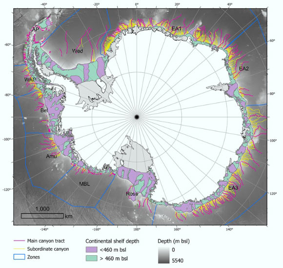
- A new study conducted by University Collage Cork and Universitat de Barcelona analyzed Antarctic submarine canyon networks using a high-resolution database, identifying 332 drainage networks with 3,291 stream segments-five times more than previous studies.
- Researchers applied semi-automated techniques using the International Bathymetric Chart of the southern ocean (IBCSO v2) with detailed morphometric parameters to distinguish geomorphological differences between East and West Antarctica’s canyons.
- East Antarctic canyons are more complex,branched systems with U-shaped cross-sections indicative of prolonged glacial activity; West Antarctic canyons are shorter,steeper V-shaped formations shaped by quicker erosional processes.
Indian Opinion Analysis
The study underscores how technological advancements like high-resolution bathymetric mapping tools enable researchers to better understand Earth’s less explored regions such as polar submarines. For India specifically, this research is significant in bolstering global cooperation in climate studies since polar dynamics directly influence worldwide ocean circulation-a key determinant in climate patterns affecting monsoons critical for Indian agriculture and ecological balance. Moreover,innovations like GIS-based scripts could inspire similar applications in India’s marine ecosystems along its vast coastline for improved conservation strategies tied to biodiversity-rich underwater landscapes.


Related Posts

Stay Informed With the Latest & Most Important News
Previous Post
Next Post
Donations


Advertisement

Loading Next Post...


